Ausangate and Rainbow Mountain
Peru
Four days, three nights. No tour, no guide, no pack animals.
Ausangate is a loop trek around a mountain of the same name in the Peruvian Andes. It is located about 100 km southeast of Cusco, and the hike takes anywhere between 4 and 8 days to complete. With different routes and itineraries available, it is perfect for independent hikers like us who prefer to follow their own schedule, although most people end up joining a tour. The entire trek is above 4,000 m, and the campsites we chose to sleep at were over 4,600 m. Acclimatisation was essential. After being inspired by the spectacular scenery around Huaraz, we were hoping the mountains, lakes, glaciers and views of Ausangate would be just as impressive. The chance to add a side trek to Rainbow Mountain, the biggest attraction around Cusco after Machu Picchu, was also a huge drawcard for us.
The day before starting, we ran all over Cusco to organise the trek. Hiring camping equipment wasn't as straightforward as it was in Huaraz, having to make enquiries in 5 stores before we found gear we were somewhat satisfied with (on the plus side, it cost less than a third of what we paid in Huaraz). We had planned to take 5 days to complete the hike, and buying food to last that long was a time-consuming task. By the end of the day, we had visited the central market, 3 supermarkets and several minimarts to source everything we needed. It was 9 p.m. before we were finally packed and ready to go.
Day 1
Distance: 17.4 km
Ascent: 750 m
Descent: 375 m
We left Cusco under a heavy layer of clouds, hoping this wasn't a sign of things to come. It was a 3.5 hour journey by bus and taxi to the starting point in the blink-and-you-miss-it village of Upis. By the time we arrived, the skies were clear, the sun was streaming down and white peaks were already in view.
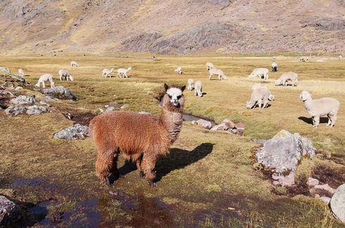
The first few kilometres meandered gently uphill on the dirt road we had driven in on, which eventually petered out to a well-formed track. Around us were bare, dry hills, while in front stood the snow-covered mountain of Ausangate. Herds of llamas, alpacas and other farm animals filled in the plains, but otherwise there wasn't much to look at.
Roughly 2 hours after starting out we arrived at Upis campsite, where one large tent was set up and a handful of hikers lazed on the ground. They would be the only trekkers we saw all day. We ate a quick lunch by the river, paid our first hiker’s fee, then continued on.
A steady uphill section brought us to the first pass, Arapa, at 4,767 m. Over the other side was a panorama of grey rocks and yellow grass, which wasn't exactly breathtaking but it was still interesting in its own way. From there it was mostly downhill in a swirling wind, with Ausangate slowly revealing more peaks and more snow.
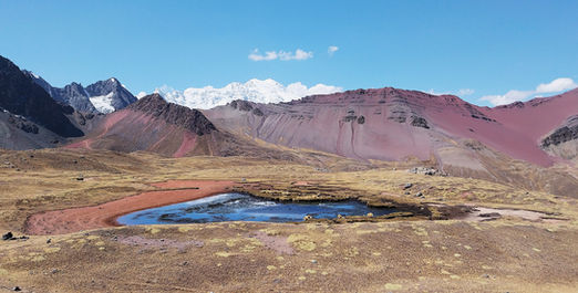
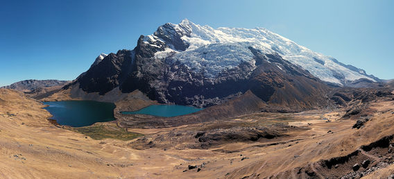
Three kilometres from the end we finally spotted our first lake. The route led us directly to its banks, where waterfalls and glaciers tumbled down towards the water. As we circled around the edge of one lake and then another, the route became more difficult. This included navigating sections of rockfall, hopping across rocks sitting in the water, balancing along the top of a waterfall, scaling vertical rock faces and losing the path more than once. It was slow going. The scenery, however, was stunning.
At the end of the second lake, Pucacocha, we spotted a hut in the distance and made a beeline for it (Maps.me told us it was a campsite). Sadly, the hut was boarded up, but there was evidence of previous campers so staked out a section of flat ground for ourselves. It was only once we were set up that we noticed a row of tents and a large wooden cabin (presumably toilets) about 500 metres back along the path but way up the the hill. We had been so determined to reach our hut that we hadn’t bothered looking around. Despite appearing far more comfortable and relatively empty, we had no energy left to pack up and move to the proper campsite. Instead, we had to rough it without toilets and a running tap, hoping that sterilised lake water would be safe enough for cooking and drinking. The sun disappeared by 5 p.m., and a chilling wind kept us curled up inside the tent for the rest of the night.


Day 2
Distance: 20.2 km
Ascent: 1,416 m
Descent: 1,306 m
6 a.m. That's the time we were woken up this morning. Not due to horses, llamas, dogs or other hikers, but because a local man was wandering past and decided he wanted a payment for camping in this spot. There was no ticket or receipt like the other fee collectors give you - he just stuck out his hand and demanded money. 6 a.m. We weren’t alert enough to argue with him, so we paid the fee then snuggled back in our sleeping bags, waiting for the sun to rise to dry the frost on our tent.
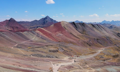
The first 2.5 km led straight uphill to Apacheta pass, sitting at about 4,940 m. Several times on the way up we had to stop to let horse and donkey trains pass. Gazing down at the next valley from the top, we could see patches of yellow and a deep purple-red hue spread across the mountains. It was our first taste of the colourful landscape we expected to see at Rainbow Mountain.
On the somewhat precarious descent, more colourful streaks were revealed to us. At the bottom our mood dampened slightly when we spotted the telltale fluorescent vest and knew we would be hit up for another fee, our third in less than 24 hours. We should have been used to fees by now, but what made it frustrating was that the author of the most recent blog I had read about the Ausangate trek mentioned that they didn't pay any fees the whole way around. I guess times had changed.
Our plan was to pass through Ananta camp, despite having solid tent shelters and running water, and camp closer to Rainbow Mountain so we could visit it tomorrow morning. The lady running Ananta camp had other ideas. She gave us a long lecture in Spanish, from which we understood that (a) apparently we were not allowed to pass; and b) something about alpacas - there were a hundred or so roaming free right next to us. We did our best to explain that we wanted to visit Rainbow Mountain, knowing that this was the main route to get there from the Ausangate loop. She wouldn't budge. Not far behind us were a French couple also wanting to visit Rainbow Mountain, but they had a guide and support staff with them. We asked their guide to translate what the woman was saying. A long heated argument between the woman and the guide ensued. In the end, we were allowed to pass if we paid her a fee (of course) and agreed to come back to stay at this campsite tonight (we had to return this way after Rainbow Mountain to continue on the trek). That wasn't our plan, but if it meant we could leave our backpacks at the campsite and spend the rest of the day load-free then we were all for it. We even paid extra for one of the tent shelters, on the hope that it would be slightly warmer and there would be less frost in the morning. At this stage we had only hiked 5 km and felt relatively fresh. Little did we know just how much more hiking we had ahead of us.
After eating a quick lunch and setting up our tent under the straw hut, we set off for Vinicunca, aka Rainbow Mountain. The first stage involved going up and over Huarmisaya pass, sitting just under 5,000 m. From the summit we saw large swaths of pink and yellow running down the slopes, as though someone had painted the landscape. We knew we were getting close now. Next was a slow descent, a flat section across a valley, then one last lung-busting push up to the lookout on Vinicunca, at over 5,000 m. Directly ahead of us was the famed Rainbow Mountain, with bands of red, pink, yellow and green draped over the bare hill. It was an incredible sight, and hard to believe that it was completely natural. Thankfully, it was late enough in the day that the crowds had left and we almost had the place to ourselves (in high season, around 1,500 people visit here every single day). Glancing out either side offered more fantastic views, with large splotches of colour covering the mountains and a bright white glacier standing out in the distance. We made our way down to the main viewpoint at the bottom of the hill, but the colours didn’t seem quite so vibrant from here. Incredibly, most of this was permanently covered by snow only 10 years ago, only being revealed to the world in 2015 due to the effects of global warming.
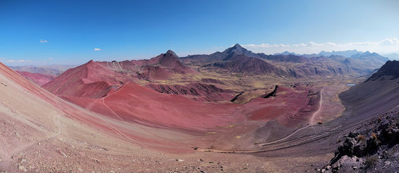
With time against us, we hurried over to a neighbouring attraction, the Red Valley, about 2 km away. It felt surreal walking across the side of a mountain with the dirt underneath our feet changing colour every few paces. The lookout over the Red Valley (again above 5,000 m) was sensational. A bright red landscape stretched out before us, contrasted by patches of dry yellow grass. Overall the entire area was otherworldly and utterly mesmerising. I wished we had more time to appreciate it.
It was a long walk back to camp and the light was fading fast. From the Red Valley we rushed back to the Rainbow Mountain and then across the valley floor. By this time the sun had dipped behind the mountain and the temperature had plummeted. An icy headwind only added to the misery. We didn't think our hike would take so long and weren't prepared for the suddenly Arctic conditions. Trying to rapidly climb back up and over Huarmisaya pass was a tough slog. We were conscious of the time but there was nothing we could do to make ourselves go faster.
Back at camp, our first priority was to immediately dress in all our warm gear before preparing dinner. The campsite had a mud brick hut that the French couple and their team were using, complete with tables, chairs and staff to cook food that was far more appetising than our instant noodles. Happily, their guide allowed us inside the hut with them, and even gave us plastic chairs to sit on that were usually reserved for the tour staff. It was almost luxury. After eating it was straight off to bed, listening to a cacophony of dogs howling to each other across the valley.


Day 3
Distance: 18.3 km
Ascent: 795 m
Descent: 903 m
There was no sleep in this morning either, with the dogs and the tour group making a start before 6 a.m. Surprisingly, the sun rose well before 7 a.m., which was much earlier than we anticipated. We left bright and early just after 8 a.m., which might be a record for us.
Our original itinerary had us visiting Rainbow Mountain this morning. However, with our change of plans yesterday thanks to the campsite owner, we could now aim to finish the whole trek by tomorrow afternoon, a day earlier than expected.
Today was not our finest day navigation-wise. The first section was an undulating 6 km trek to Lake Ausangate, past red mountains and valleys filled with alpacas. There were numerous trails leading across the hills, and we found ourselves off track for at least a kilometre. After jumping many fences we located the correct path, which turned bright crimson as we headed towards Ausangate Mountain.
To reach Lake Ausangate, we detoured slightly off the main trail. The view wasn't exactly worth it, even with the vast glacier hanging down above it. A fee-collector soon found us, the fifth so far (and counting). From the lake it was a steep, lengthy climb up to the only pass for the day, Palomani, sitting at 5,135 m. We were grateful when it was over.
Coming down from the pass we had 2 options: the obvious, straightforward route or the trail that was barely visible, slightly shorter and, on the map, looked like it would take us past more interesting scenery. Of course we chose the latter. Using Maps.me, we followed the path down to an empty lodge, admiring the foreboding glaciers and a pink lake on the way. From there we did our best to stick to the trail, constantly referring to the map to see if we were walking the right way but having to backtrack repeatedly. When it led us to an almost vertical jumble of loose boulders, our frustration boiled over. If the trail continued like this, we wouldn't be making camp before dark. Once we had cautiously made it to the bottom of the rocks, we decided to give up on this route. Instead, we decided to cut across the valley floor to find the apparently correct, easy-to-find route. This involved more fence jumping, more alpacas plus a vicious, snarling dog, who we were sure would have attacked us if we hadn't swung our hiking poles around wildly while shouting loudly as a defence (don't worry, we didn't hit the dog). It was the scariest moment of our entire time in South America.
After a few more kilometres we turned up another valley, where the colourful mountains disappeared. It was gently uphill the whole way, following a bubbling river and staring at a gigantic 3-pointed glacier ahead of us. A chilling wind that had been following us all day suddenly intensified. By 3.15 p.m. we were walking in the shadow of the mountain, the air suddenly freezing. Five minutes later we arrived at camp, where we immediately set up the tent and dived inside. This was the busiest campsite we had seen, with the French couple, 2 other tents on a tour, plus another independent couple doing a 6-day trek. It was also the most well-equipped site, with flushing toilets and a store that sold bottled drinks. We didn't mind paying a fee for this one. It had been another long day for us, adding a couple more kilometres than expected with our off-trail adventures, and we looked forward to an early night.

Day 4
Distance: 17.7 km
Ascent: 660 m
Descent: 965 m
Overnight wind ensured our tent wasn't covered in frost in the morning, which was a nice change. The sun hit us early again, but a thin layer of cloud meant the warmth didn't penetrate as much as usual. While we appreciated the running water and flushing toilets last night, this morning they were both frozen solid, as was the small creek beside the campsite. Luckily we had enough water for breakfast and to get us through to the next water source.
It was bitterly cold when we commenced hiking. The first 6 km were gradually uphill to our final pass, alongside looming glaciers and tiny lakes. Ice covered parts of the path, and the sections that had melted had turned into a muddy mess. Usually when we ascend we warm up quickly, but not so today. The fierce headwind pushed us back continuously and froze us to the core. We were completing the Ausangate trek in an anticlockwise direction, and I think the wind had been doing clockwise laps around the valleys the entire time. We never seemed to escape it.
Jampa pass, at 5,050 m, eventually arrived. On the other side we edged along the side of a scree slope that gradually descended towards the valley below. The wind eased off slightly on the way down but never fully dissipated. Around every corner more glaciers appeared - it was the most ice we had seen on the whole trek.
It wasn't long before the start of a section called the Seven Lakes came into view. Over the next couple of kilometres, we passed lakes of all different sizes, colours and clarities. Some were only a few metres wide, some stretched for hundreds of metres. Some were so clear we could see all the way to the bottom, some were milky blue. Combined with the glacial backdrop, the setting was second to none.
Once we had left the lakes behind, there was nothing else to do but go straight down to the finish point in the village of Pacchanta. It was easy walking and we covered the terrain quickly, arriving by 2 p.m. Unbelievably, we didn't pay a single fee today.
Pacchanta wasn't the prettiest of villages, but it did have one thing going for it: hot springs. We sidestepped the offers of transport and accommodation and made a beeline for the pools, which were evidently popular on the weekend. It felt amazing to scrub off 4 days worth of dirt, dust and sweat then just lie in the steaming hot water, staring out at white peaks and herds of alpacas.
Emerging from the pools was extremely difficult, as the air temperature was in the single digits and the wind hadn't abated. While dressing in our warm clothing we met 2 other hikers who had also finished today. They were catching a colectivo straight back to Cusco this afternoon, without having to make the usual transfer in the town of Tinki (apparently it was a new route, which was why we hadn’t heard about it before). Although we had planned to stay in Pacchanta tonight before making the lengthy return journey tomorrow, this option sounded much more appealing. Luckily there were seats still available, so we gladly hopped on board and drove down to the warmth and comfort of Cusco.


