Hiking in Hong Kong
Lantau Trail (1-6)
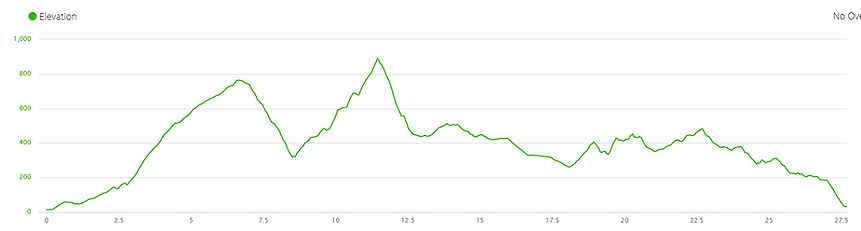
Distance: 27.5 km
Time: 7 hours 7 minutes
Ascent: 1919 m
Date: June 2019
Start: Mui Wo
End: tai O

Do this hike if:
-
You want views over all sides of Lantau
-
You think endless steps are a great training tool
Avoid this hike if:
-
You want a peaceful, secluded experience
-
You're after a shady, gently undulating hike

The Lantau Trail, the last of Hong Kong's four long trails that I was yet to conquer. At 70 km long (although my watch said a little shorter), it makes a giant loop around Lantau Island, starting and finishing in the seaside town of Mui Wo. Waiting for two rain-free days in a row, on a weekend, when I had nothing else planned, turned out to be a year-long endeavour. When it finally arrived, I blocked out the time in my diary and eagerly set out to see what Lantau would offer.
Weather forecast for day one: "Extremely hot - stay indoors". Of course I paid no attention to this and jumped on the ferry to Lantau. On the trip over I stared at where Sunset and Lantau Peaks, the two tallest mountains on the island, should have been, but all I could see was one large cloud mass. This was how it looked most days, but I was quietly hoping that a miracle would happen and they would be clear when I reached them. I didn't like my chances.

Section 1: Mui Wo to Nam Shan (2.5 km)
I walked up a road. It was incredibly boring.
Section 2: Nam Shan to Pak Kung Au (6.5 km)
The mundane road finished and the real trail began, which in Hong Kong can only mean one thing: stairs. If there is an off-road section, it is rare to go for more than a few minutes without seeing some form of step, whether it's concrete, stone or dirt. As much as I dreaded the thought of climbing a never-ending staircase, it was definitely preferable to bitumen, and the shade provided respite from the already blazing sun. Every now and then a gap in the trees opened up, and the increasing distance above sea level allowed me to slowly measure my progress. In general, though, all I saw were the 90 degree angles formed by the steps below my feet.
Something I hate more than steps, and even more than road, is spiderwebs. I always know when I am the first person on a trail in the morning, as the sticky silk latches on to me every few strides. And it's not just having the web on me - with the webs come spiders. Large ones. As in the size of my face. The golden orbs are ubiquitous in Hong Kong, and this trail was no exception. Each time I felt the thread sweep across my skin I instinctively brushed my hands through my hair, certain I had picked up the web's host as well. After running into two spiderwebs I started to learn my lesson, and commenced to look up as I walked rather than down at my feet. I was ducking and weaving like a boxer training for an upcoming match, but obviously not a good one as I still ran into dozens of the mesh networks. I guess that's the price I pay for starting early.
About halfway up Sunset Peak I hit the clouds, reducing visibility considerably. The positive, though, was the lack of direct sunlight coupled with a slight breeze, which momentarily slowed down my rapid sweat rate. Periodically an opening would appear, giving me glimpses of the scenery out towards various parts of the island, but for the majority of the time it was just me and the stairs.
As a way to pass the time I had started counting the steps when I commenced this section. I gave up after 2000.
The summit (or as close as the trail gets to the top) was an unceremonious event, surrounded by a grey blanket that gave me zero reward for my effort. My legs were relieved to have made it, but my head knew there was plenty more ascent coming my way. With no reason to linger, I continued on without pause. I had climbed a million or so steps to reach this point, and now had a million or so more to reach the bottom on the other side of the mountain.
Halfway down I emerged from the haze, where the kaleidoscope of colours hit me with full force. I felt like Dorothy in the Wizard of Oz, transitioning from black and white Kansas to the bright hues in the Land of Oz. The rolling hills, coastal scenery, the occasional flower, and even a paraglider over the water were impressive enough to have me stopping every few moments to take another photo. Ahead of me I spotted the lower half of Lantau Peak, with the upper portions shrouded in another layer of cloud. Despite this, I knew exactly where the trail was leading me, and I knew it was going to be a tough slog.


Section 3: Pak Kung Au to Ngong Ping (4.5 KM)
The downhill ceased and the uphill resumed, and of course it was all stairs. The sun was beating down, the sweat was pouring off me, and when I looked up there was no relief in sight. So I put my head down and set one foot in front of the other, trying my best to think about anything other than what my legs were currently doing.
As it was a long weekend and the yearly Dragon Boat Festival was on, I presumed I would have the trails almost to myself. I couldn't have been more wrong. My dreams were quickly shattered as I found scores of others were also making the climb up Lantau Peak, the tallest point on Lantau Island. I didn't mind so much that I had to dodge other hikers and their dogs while climbing the stairs. What did annoy me, however, was the incessant blare coming from the countless Bluetooth speakers I passed along the way (this is one of my pet peeves that I encounter on nearly all of my hikes). Most of the music consisted of traditional Chinese songs, which to me sounded like cats screeching while they played out of tune stringed instruments. I glared angrily at the offenders as I stomped by, frustrated that my peace and tranquility was being interrupted by the noise I was trying to escape from. I'm pretty sure they didn't notice my scowling facial expressions.
Once again I reached the clouds at roughly the halfway point, where the air temperature immediately dropped 10 degrees (so it was just 'really hot' rather than 'very hot'). As I couldn't see the top I had no idea how far I had to go; I continually told myself that it was only one more staircase, one more push. To repeatedly find out this wasn't the case was a little disheartening, but breaking the trek down into manageable chunks seemed to help me to persevere, even when my body was telling me to turn around and take the easy way out. Like on Sunset Peak the clouds would part intermittently, confirming that I was making headway as the valley and sea below crept further and further away.
When I was sure I was only moments from the summit, I suddenly popped up above the clouds. Here there was scorching sun, blue skies and nothing to obstruct the view above me. While I was glad to be distracted by the surrounding scenery, it also confirmed my fears: I was nowhere near the top. Way above me other hikers were still climbing the relentless stairs, all with the same destination in mind. I was sure I had been going upwards for an eternity - how could there be so far to go? I immediately wished the clouds would come back over me.
Another million or so boulder-sized steps later, I at last summitted the peak. And it was fairly underwhelming. No sweeping views, no postcard-perfect panoramas, just the sight of a few rocks lining the slopes below me before the clouds started again. Thanks to Google I knew what could be seen on a clear day, but that definitely didn't match what was before me. With that disappointment I decided to head down straight away, rather than hang around for an indeterminate amount of time, waiting for a possible clearing of the clouds that would give me the sights I was after.
By my calculations I had climbed a billion steps up to this point, so that meant it was approximately a billion all the way down again. Down over the giant boulders, down into the clouds, breaking through to the colourful Land of Oz, catching snippets of views through the trees, and ultimately arriving on flat ground, the first I had seen all day. At this location was a tourist attraction called Wisdom Path, consisting of 38 wooden columns inscribed with lines from a revered Buddhist prayer, the Heart Sutra. Unsurprisingly, the place was packed with tour groups and day trippers. I rushed through the crowds, relishing the lack of elevation change but also eager to find some solitude once again.


Section 4: Ngong PinG to Sham Wat Road (4.0 KM)
Naturally, the horizontal path didn't last long, and it soon made a turn towards vertical. Stairs appeared before me, causing me to take a deep breath before starting the ascent. Thankfully, this time there weren't million of steps. Not even thousands. There were just a few hundred, but this was enough to bring the burn back to my quads. I slowly made my way through a quiet forest, unusually circling around a peak rather than climbing straight to the top of it. Although there were no jaw-dropping vistas in this region (just the odd glimpse out to the Big Buddha statue), I cherished how quiet the area was - I couldn't see or hear another soul. Perfect.
That was until I reached Ngong Ping 360, a tourist village at the top of the Lantau cable car that can be described in one word: tacky. It was entirely set up for foreign visitors, with fake, overpriced souvenirs and expensive restaurants. It was here that I ran into a throng of tourists, and I couldn't force my way through the crowds and the noise fast enough. The only reason I briefly stopped here was to say hello to a handful of adorable cows lying down around the outer perimeter, enjoying tiny patches of shade they had acquired. The peaceful animals paid no attention to me or the others creeping forward to take photos.
After I had squeezed through the hordes, I ended up on a road that took me downhill towards the sea for a couple of kilometres. The sole points of interest along here were the occasional lookouts over the bluest reservoir I think I had ever seen, surrounded by lush green mountains and the sea beyond. It was stunning enough to warrant more than a few photo stops (but honestly, it doesn't take much for me to pull my camera out). Section four ended when the road did, and I was finally back on the dirt again.


Section 5: Sham Wat Road to Man Cheung Po (7.5 KM)
The fifth section commenced like every section before it: heading up. For a kilometre I climbed stone steps in the sweltering heat, which were surprisingly laid out in switchbacks (Hong Kong usually likes to go straight up and straight down, no messing around). At the top I was met with the best sight I could imagine: rolling hills, way above the valleys below, with sea views to top it off. Although I wasn't nearly as high as I had been on Sunset and Lantau Peaks, I still felt as though I was on top of the world.
The terrain varied between steps, dirt and long grass, while the views showed off the charm of Lantau's southern coast. There was hardly anyone around, and it seemed like I was a million miles away from civilisation. It was as though the weight of the world was lifted off my shoulders, a sensation I don't experience often in daily life. Despite being the longest section of the day, it was my favourite by far.
Once I started the long descent I knew I would be losing the lookouts and the wide open space. The forests came up to meet me, and all that remained were my memories of the beauty above. But I didn't mind - I had loved every moment on top of the mountain range, and now it was time to make my way towards today's finish line.


Section 6: Man Cheung Po to Tai O (2.5 KM)
This section felt like a filler, just a way to get from the incredible undulating mountaintop trail down to Tai O, a traditional fishing village. Most of the route was composed of a steep concrete path, taking me back down to sea level. Along the way I passed a lake covered with lily pads, out of place in such a dense, unruly forest, and I caught a sneak peak of Tai O just before I reached the town. Mostly the pavement was quite boring, and I was impatient to reach the end. The shade was appreciated though.
In Tai O the serenity I had derived so much joy from in section five was wiped out in a matter of moments. The crowds of Ngong Ping 360 had apparently transported themselves to the stilt houses and seafood stalls that make this village so popular. I was desperate for water, having run low for the previous two hours, and every step was a struggle to push my way through the pack. I eventually emerged, unscathed and with drink in hand, but the thought of sight-seeing was not high on my list of priorities at this point in time.
Day one was complete! Although I had only covered 27.5 km out of 70, I had ticked off the major peaks and a fair chunk of the total elevation change. Tomorrow was going to be a long day to complete the final 42.5 km - my only aim was to finish before dark. For now though, all I wanted was food, a shower and sleep, in that order, and I would worry about the next day's hike when I arrived back here bright and early tomorrow morning.