Hiking in Hong Kong
- Ngong Ping 360 Rescue Trail -
- Nei Lek Shan Country Trail-
- Shek Pik Country Trail-
- Dog's Teeth Ridge- -Nei Lek Shan-
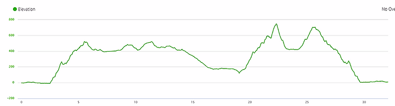
Distance: 32.1 km
Time: 9 hours 10 minutes
Ascent: 1862 m
Date: July 2018
Start: Tung Chung MTR
End: Tung Chung MTR

I had one rain-free day to explore Lantau Island, so I scoured the maps and pieced together a route covering several different trails. This changed a few times, both the day before and in the middle of the hike. In the end I felt like I covered a huge chunk of the island, but looking back at the map it was just a small fraction of what was possible. I guess I need to plan a few more days out on Lantau.

Ngong Ping 360 Rescue Trail
Do this hike if:
-
you want to get your leg workout in for the week
Avoid this hike if:
-
you're after a real trail
From Tung Chung MTR I followed the walking/cycling path out to Tung O Ancient Trail, a route I had explored before, and walked along here until I came to the start of the Ngong Ping 360 Rescue Trail. The path followed the cable car straight up the hill, and I presumed everyone else would be smart enough to take easy option to the top. Wrong. The route was full of other hikers, and was obviously a popular Sunday hiking spot.
The first step on the trail was a step. Almost every other step on this five kilometre route was a step. It was all steps. They varied between stone and wooden, with no dirt (i.e. real trail) sections. Somehow the sun was blistering at 7.30 am and after half an hour of nothing but ascent (accompanied by pools of sweat) I was wondering if I had the motivation to make it to the end. I take a while to warm up when hiking (and running) so the first stretch is always tough, but this had me seriously considering turning around. The only things that kept me going were the views over Tung Chung and the surrounding mountains on the way up, plus what I hoped would be an epic outlook from the top. At least I couldn't get lost.
When I started climbing a local man was right behind me, blaring loud Chinese music from some sort of electronic device. It took me 10 minutes before I could finally walk fast enough to get away from him and his incessant noise, and this was possibly the only reason I kept going and didn't quit.
After a while the views turned from beautiful to ugly, as the airport came into view and took away from the picturesque landscape. I kept my eyes trained either straight ahead (at steps) or high above me, watching enviously as tourists took the leisurely route to my destination. I was also envious of all the people I passed coming back down the hill, smart enough to start the trek before the heat of the day set in.
Thankfully, after 3 km the steep inclines stopped and the path became more undulating, making for a much more pleasant experience. It was still all paved/boardwalk, but now I felt like the end was achievable.
The route was called Ngong Ping 360, which ended on top of a hill. With a name and location like that, I expected big things. I was severely disappointed. There was not one single lookout point in the entire area. I guess the 360 part referred to the cable car ride up here. At the top was a village full of restaurants, shops and entertainment venues, ready to suck the money right out of your wallet. Luckily I had arrived before the crowds did, but I'm sure in the middle of the day it would be swamped. I walked through here as quickly as possible, ready to hit a proper trail.
I had walked 7.5 km to reach this point. The first 2.5 km were flat. The last 2 km were undulating. Those 3 km in the middle had me gaining almost 600 metres of elevation. I really need more of a warm up before tackling something so intense.


Nei Lek Shan Country Trail
Do this hike if:
-
you want a beautiful trail without steep climbs
Avoid this hike if:
-
you like more intensity in your hikes
Nei Lak Shan Country Trail started just a short walk from NP 360, down a flat road lined with camp sites and hostels. I could see Lantau Peak, the tallest mountain on the island, on my right, and I was extremely glad that wasn't on my itinerary today. The skies were clear and the summit was unusually visible, which did make me consider momentarily of taking a detour up another several hundred metres. But it was far too hot and I was over climbing for the time being. It would have to wait for another day.
As soon as I turned off the asphalt my feet hit the dirt, and I knew I was going to love this trail. The entire 5 km route was gentle rocky slopes, making it much more enjoyable than the Rescue Trail. There were lookout points from all sides as it circled around Nei Lak Shan mountain, providing views of the Big Buddha (a 34 metre high bronze statue), Ngong Ping Village, Tung Chung, the mountains of Lantau and the surrounding sea (plus the ugly airport). A small forested section granted me some respite from the sun, and the carpet of dead leaves lining the track gave it an enchanted feel. Part of the trail doubled up with the Lantau Trail, and I saw a few people along here, but the rest was almost empty. It was the type of trail I could have walked forever.
Two things distracted me from my serenity. The first was another hiker, an Indian expat living on the island, who decided I was to be his best friend. For 10 minutes he asked me every question under the sun (What is your name? Where do you live? Where do you work? Where do you come from? Where did you start today? What time did you start? What trails are you doing today? Where will you finish? Why don't you sweat?). He was genuinely a very nice man, but my purpose for this hike was to be alone, not to be social. I stopped for a while at a lookout point to take photos, where he decided I was taking too long and he continued on his way. To my fellow hiker, If you happen to be reading this, I apologise for being so rude.
The second unwanted incident was a snake. Not big, not small, but it stopped me dead in my tracks. I waited for him to slither off before cautiously continuing, my eyes peeled for further reptile encounters.


Shek Pik Country Trail
Do this hike if:
-
you want a runnable trail
Avoid this hike if:
-
you are looking for inspiring scenery
From the end of one country trail I walked along a short segment of the Lantau Trail over to another. The start was located at Wisdom Path, where a series of wooden pillars were erected. Each pillar was engraved with a line from a Buddhist prayer, entirely in Chinese. I did a loop around the tall posts, but as they meant nothing to me I didn't stay long.
The Shek Pik Country Trail runs gently downhill all the way to the south of Lantau Island, following Shek Pik Reservoir. I was looking forward to the descent as well as decent views, even though I knew I would need to come back up at some stage. The downhill I got; the views were barely there. On only three occasions did I glimpse a view of the reservoir and surrounding scenery on the whole 5.5 km route. Each view was exactly the same, but slightly lower in altitude. The rest of the time I was surrounded by trees and there was nothing noteworthy to look at. Great for running; a little mundane for hiking.
The terrain was almost entirely rocky trail, with a series of stairs at the end. I was happy it wasn't paved, but the loose rocks coupled with the declining gradient meant my toes were well and truly squished by the end. This didn't help to improve my impression of the trail. The only saving graces were that it was shady (the heat was intense today) and that there was a tiny section with pine trees, giving off a lovely pine aroma. Pine always brings back fond memories of my childhood and I don't see much of it in Asia.
I saw another snake. Again, not big, not small, just casually crossing the path in front of me. I can't believe how many snakes I see in Hong Kong.
Just before I reached the end I heard the sound of cars, so I knew I was near the main road. Here I had a choice: either circle around the reservoir and follow the road back up the hill on the other side, which would probably be monotonous but might bring me some different views. Or I could follow one of the faint lines on my map to take me up to a peak I had never heard of, Kau Nga Ling. This would no doubt involve much more climbing, would definitely be on a trail and would likely take much longer than the road. One guess which one option I chose.


Middle dog's teeth ridge (Kau Nga Ling)
Do this hike if:
-
you want epic views with an element of danger
Avoid this hike if:
-
you're a law-abiding citizen with no desire to risk your life for the sake of a good lookout
To reach the start of the path up to Middle Dog's Teeth Ridge, I had to retrace my steps back up the Shek Pik Country Trail for almost a kilometre. I can guarantee I would have missed the turn-off if it wasn’t for my phone. Even though the entrance was signposted, it still didn’t look like there was a trail there at all.
The sign wasn’t something I wanted to see. It informed me that injuries and deaths had occurred in this region and kindly requested I don’t continue. I debated with this for a while, but looking at the three coloured ribbons marking the path I decided that other hikers must use this route too, so I continued. I was glad I did, although I found out later why the sign was there.
Initially the trail was almost completely overgrown, and several times I had to bend over double to make my way through all the overgrowth and low hanging branches. I pushed aside plants and leaves as much as possible while climbing steeply uphill, knowing that this was going to be a long journey. While it was definitely technical and the vegetation carved up my legs, I didn’t see how it was that dangerous.
When I emerged from the dense forest I was met with a grassy, rocky incline, which definitely made for slow going. The sun was beating down and I was pushing aside long grass to inch my way forward. I could see the peak ahead of me, with Lantau Peak beyond that, and once again I was glad I wasn’t summiting that today. The hiking was difficult, but not deadly.
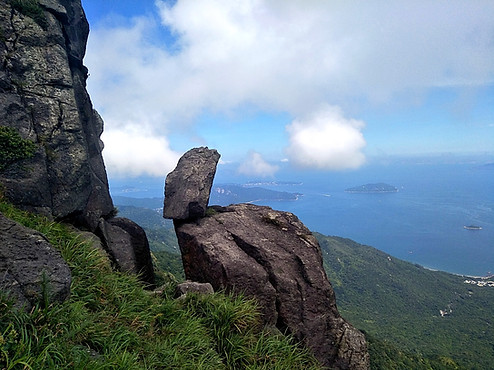
I scrambles up precarious rocks to reach the peak, where I was met with breathtaking views of the reservoir, the sea and islands further out. It was stunning, but it didn’t take anywhere near as long as I expected. I checked my phone to see where to go from here, only to discover that I wasn’t at the peak yet. Not even close. The giant mountain in front of me that I presumed I would be bypassing - that was the peak. I had a long way to go.
I met up with two other hikers along here who had climbed up via a different route. They stopped in front of me to put on hiking gloves. Gloves? Why would they need gloves? It didn’t take me long to discover that this wasn't their first time here.
That peak that was way above me didn’t require hiking skills - it required rock climbing skills. I was hauling myself up close to 90 degree inclines, desperately trying to squeeze my toes onto narrow rocky ledges and turn my knees outwards to take the next step. I leaned into the rock as much as possible, knowing that one slip and I would be gone. Surprisingly, I wasn’t scared at all. I was hot, sweaty, breathless, but not scared. It was just one foot above the other all the way to the top.


The path wasn't always visible (picture 1: that's the path, right in front of me.
Along the way there were flatter sections intermixed with the rocks, giving my upper body a break, but invariably the rock climbing returned. I purposefully took it slowly, making sure to secure a strong grip on the rocks before making my next move. It took me 35 minutes to cover one kilometre. 25 minutes for the next one. One hour, two kilometres. This was not a place for setting speed records.
The actual peak was just as spectacular as my false summit, with a strong wind helping to cool me down, but the clouds had started to come across now. The heat made the landscape hazy, so the photos weren’t the best, but I was ecstatic to have made it. I met two more climbers here, coming up from yet another route, so I guess I wasn’t the only who ignored the warning signs. This section was by far the best part of the whole day. It would be better if it wasn’t officially off-limits.
The climbing hadn’t finished. There was still more mountain and rock to ascend to make it to the Lantau Trail, just below Lantau Peak. The danger levels didn’t subside, forcing me to use my whole body to clamber up sharp outcrops. Somehow this part still felt easier than the stairs of the Rescue Trail. It looked like the perfect place for snakes to hang out, but I didn’t see one at all on this segment.
There was a huge sense of relief once I made it to flat ground again. Not that it stayed flat for long. I briefly considered taking the stairs up the Lantau Peak – what’s another couple of hundred metres (both horizontally and vertically)? But the clouds had started to obscure the summit, so I thought better of it and made my way down millions of uneven stone stairs back to the Wisdom Path.
I googled Kau Nga Ling when I got home to find there were three different routes to the top, of which I happened to take the hardest. One of the rock climbing sections is known as “a slim chance of survival” due to its sheer incline. Another website suggests that the trail is “only suitable for extreme hikers”. Maybe I should do more research before I undertake these adventures.


Straight up and over.
Nei Lek Shan
Do this hike if:
-
you like great views without the crowds
Avoid this hike if:
-
you like seeing your feet
From the Wisdom Path I followed the Lantau Trail back to the Nei Lak Shan Country Trail and retraced my steps along the start of the route. A few minutes later I turned off up an unmarked narrow track heading straight for the peak. It didn't look like many people explored this path.
Ten minutes later I was standing on the top, taking photos of everything I could see around me. Just like my first thoughts on Kau Nga Ling, it felt like an easy summit. And just like Kau Nga Ling, it wasn’t the summit. For some reason I didn’t see the huge mountain behind the flat bit of ground I was standing on. I was in for a tough climb.
The flat turned into steep almost immediately. Not rock climbing steep, but snail pace steep. The majority was so overgrown I had difficulty seeing the path at times. To add an extra element of fun there were signs warning me about high voltage cables in the area, and several times they crossed over the track at ankle height. This was another section I swore I would see snakes, but thankfully none were around.
The peak was at an altitude of 700 metres, meaning I had clear views in most directions. There wasn’t a soul around, and I could see many of the trails I had already hiked that day. It was the final climb of my trek, and I was looking forward to reaching the bottom and making my way home.
I thought it would be a fairly straightforward descent, but of course nothing is that easy. Thick scrub and long grass covered most of the track, and for a large chunk of time I couldn’t see my feet below the vegetation. The path was rocky and uneven, causing my feet to slip and roll when I didn’t get a stable foot placement. I ended up lifting my feet high to avoid tripping over any unseen objects. I think it took me longer to get down that it did to go up. When all I wanted to do was reach the finish and collapse into a chair, this caused me high levels of frustration.
When I finally made it back down to the Country Trail I cut through a short grassy area (where I could see where I was stepping) to land back on the Rescue Trail. Three kilometres of stairs carried all the way back down the hill, and then a flat, solid path took me to the train station. Over nine hours of hiking with very few flat segments meant my legs would probably be calling for a rest day tomorrow. Overall I loved how much I got to see and experience on the hike, and was lucky enough to have great weather (not easy in wet season). I’m definitely looking forward to my next trip to Lantau.