Patagonia National Park
Chile
Just when you think the Carretera Austral couldn't get any better, it does. From Chile Chico (the town we stayed at while exploring Jeinimeni), an unpaved, mountainous road hugged the coast of Lago General Carrera, the second largest lake in South America. Turquoise water shimmered in the foreground, while snow-capped mountains sat behind. It was late in the day and the sun was unfortunately right in our eyes, so we didn’t have the greatest views. As the Chileans don’t seem to be a fan of safety barriers, it was a nerve-wracking 3-hour journey to Puerto Bertrand, with a sharp drop-off right beside us. However, it was made much more enjoyable by the natural scenery beside us. Hiring a car was one of the best decision we made in Chile.
Lagunas Altas
Distance: 21 km
Hiking Time: 5:10 hr
Ascent: 1,065 m
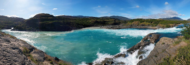
On our way to the start of our first hike in Patagonia National Park, we stopped at the Confluencia Viewpoint. Here, the stunningly blue Rio Baker met with the dirty brown Rio Nef to create a greenish-coloured river that travelled down through a canyon. As the viewpoint was almost at water level we couldn't appreciate the full spectacle, but it was worthy of a photo or 2 (plus the 20-minute walk). A second Confluencia Viewpoint appeared near the entrance of the park, this time where Rio Baker met Rio Chacabuco. It was a much higher vantage point but the river was way in the distance and therefore less impressive than our first stop.
There were many hikes on offer in this region, but the Lagunas Altas (High Lagoons) loop was advertised as the most popular. I wasn’t sure how accurate that information was, as we only saw one other couple the entire day. The registration office was located at the fanciest park headquarters we had ever seen - it felt more like an exclusive golf resort than a place to go hiking. Several guanacos were calmly wandering around, unafraid of humans. Once we had checked in, we left the opulence behind and drove a further 2 km down the road to the beginning point of the trek.
We commenced by steadily plodding up a grassy hill for many kilometres, which was fairly mundane except for a long-busting kicker at the end. At the top we met more guanacos, grazing on the plains, before we reached our first lagoon. The water was a sparkling intense blue and incredibly clear, appearing almost like a desert oasis. I could have imagined it as part of an advertising campaign for some remote part of Australia if it weren't for the white peaks in the background.
For the next couple of hours we hiked past lagoons of all shapes, sizes and colours (mostly brown). Some were hidden through the trees, some had reeds and grass poking up through the surface, while others were home to families of ducks. In between the lagoons were sections of forest, many of which looked like tree cemeteries with dried logs and branches strewn about (this was also reminiscent of outback Australia). It was fairly easy walking through the picturesque setting, even if a few of the lagoons weren't so pretty to look at.
It ended how it started, on a grassy hill, but this time we were going down and we were treated to views of enormous boulders on one side and distant lakes on the other. Overall it had been a straightforward, easy-to-navigate hike on mostly stable terrain, and the reminders of home had given it a special touch.

Aviles Loop
Distance: 16 km
Hiking Time: 3:37 hr
Ascent: 628 m
The following day we drove further into the park to tackle the Aviles Loop, a 16 km route that ventured up a valley on one side of a river then back down the other. On the drive in we passed several herds of guanacos lining the road, only moving out of the way at the last moment. This region was definitely a must-visit for guanaco fanatics.
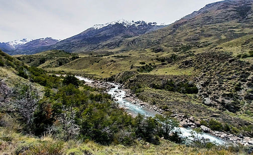
For the first 2 km we meandered along a flat trail leading into the heart of the valley. Suddenly the path took a sharp turn up the side of the mountain along a series of loose gravel switchbacks, the view gradually expanding the higher we climbed. At the top, the path undulated across open plains far away from the edge of the valley. Only occasionally were we afforded glimpses of the river stretching out before us with small patches of snow in the distance. It wasn't the most enthralling hike, but it was pleasant enough if we considered it a gentle stroll on a summer’s day.
After another climb further up the slope we descended down to a river crossing, marking our turn around point. A sketchy suspension bridge crossed over a deep canyon, the water surging through a narrow channel underneath. Despite the lack of wind, the bridge bounced wildly with each step. It took nerves of steel to cross over to the other side. I wasn't surprised to hear that some people opted not to cross and instead returned the way they came. At least the view of the canyon somewhat made up for the thoughts of plummeting to our deaths.
As we were returning down the other side of the valley we hit another river, with no discernible way to traverse it. We searched up and down for rocks to jump across, but they were all submerged in gushing water. With a lack of alternatives, we removed our shoes and socks and eased through the icy water. The coldness was ridiculously painful and I couldn't escape the river fast enough. Attempting to put toe socks back on wet feet was also not an enjoyable experience.
Most of the remainder of the hike was through flat fields, with no wildlife or decent scenery to be admired. Eventually the path led back down to the valley floor, crossing over another one of the wobbly bridges. It was far less scary when it was only a metre above the river. Looking back, the trek wasn't going to rate highly on our list of expeditions in Chile, but any day spent outside in nature is a great one in my book.


