Puerto Rio Tranquilo
Chile
There are 2 reasons people visit the tiny lakeside village of Rio Tranquilo: glaciers and caves. We planned to conquer both.
Exploradores Glacier
Distance: 9.2 km
Hiking Time: 3:45 hr
Ascent: 257 m
The Exploradores Glacier lies about an hour’s drive from town along a bumpy road (we hadn't found many paves roads yet, and the ones that were paved were full of potholes). Thankfully we weren't driving this time, as we had joined a tour to trek along the glacier. We had skipped the Grey Glacier hike on the O Trek in the hope that Exploradores would work out for us (expeditions were very weather dependent). Other than low-hanging clouds and sprinklings of rain, conditions were good.
From the visitor’s centre it was a 10-minute stroll through the forest to our first viewpoint, where we could see blue icy peaks sticking up far in the distance. After another 20 minutes alternating between forest and rocks, we arrived at the edge of the glacier, although we barely knew it. All we saw were mounds of dirt, gravel and rocks that looked more like a construction site or a quarry than a glacier. Ugly was the word that came to mind. Apparently, underneath it all was a solid block of ice, but it wasn’t visible to us just yet. This was where we spent most of our day.
The trek was slow going. Walking up and down the rock piles took all of our focus, each step threatening to twist an ankle or send us sliding down the mounds. Occasionally a slick patch of ice would poke through the dirt, its appearance jet black due to the lack of daylight reaching it. In the valleys between the mounds were ponds of grey, muddy water that didn't improve the mundane scenery. Occasionally we came across stark white slopes, reminding us that there was actually a glacier beneath us.
Besides the two of us, our group consisted of 2 guides and 4 Brazilians. The Brazilians were keen photographers, and I can’t stress the word ‘keen’ enough. Every couple of minutes they stopped for another photo shoot, with every possible combination of people in multiple poses using all cameras they had brought with them (4 phones, a DSLR and a GoPro). It quickly became infuriating. Group after group passed us and disappeared out of sight, while we stood around in the cold waiting for the next round of photo .
Two hours after starting out we reached the edge of the exposed ice, where our glacier trek would begin. All the other groups had long since commenced. Once we had put on the crampons, gaiters and harness, we could finally set out directly on the glacier. Initially the ice was flecked with dirt, so it wasn't the prettiest section to walk on. It took a bit of practise to get used to crampons again, having to trust that they would hold our weight up and down the short but steep slopes. The ice stretched out before us in rolling waves, where a sporadic crevice or fissure would shine a brilliant blue. Our guide bent down and filled his water bottle from a puddle, insisting it was okay to drink. Given the amount of dirt around, I wasn't in a hurry to do the same.
The best part of the trek was exploring a cave. Two adjacent entrances led down several metres under the ice, each shining an impossible shade of glacial blue. At the end was a vertical tunnel that led back to the surface of the ice above us, with water trickling down the sides. Before I knew it, I was roped up and told to start climbing up the wall. It turned out that I was useless at ascending ice tunnels, and the only reason I emerged at the top was because the guide pulled me up most of the way. It was still loads of fun.
After this we stopped for a lengthy lunch break, staring out at the prettier, cleaner peaks of the glacier. This was to be our turnaround point, which was disappointing as the other groups had travelled out much further than us (thanks Brazilians...). The tour had advertised spending 2 hours on the ice, but in the end the technical trekking part that required crampons was only half an hour or so. I had truly enjoyed hiking on the glacier; I just wished it hadn’t been over so quickly.
As we were returning on the gravel section the sun decided to make an appearance, but there was nothing to take photos of other than rocks, rocks and more rocks. It seemed to take an eternity to cross the unstable terrain, and it was with relief that we eventually stumbled into our van and travelled back to Rio Tranquilo.

Marble Caves
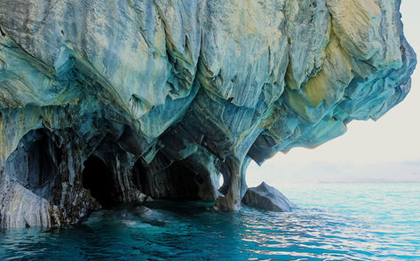
The second reason for visiting Rio Tranquilo was to visit the Marble Caves, which also required us to join a tour. This one was of the boat variety, where we could sit down the entire time and not have to worry about other group members holding us up. We were kitted up with ponchos and life jackets before being herded onto the open- air boat to set sail across the turquoise Lake General Carrera. The water was very choppy, causing us to bounce uncomfortably across the surface of the water. Our driver didn't think this was enough fun, so he opened the throttle and we dashed across the lake at a dangerously high speed. Water sprayed over us continuously, which was apparently part of the adventure. No wonder they gave us ponchos.
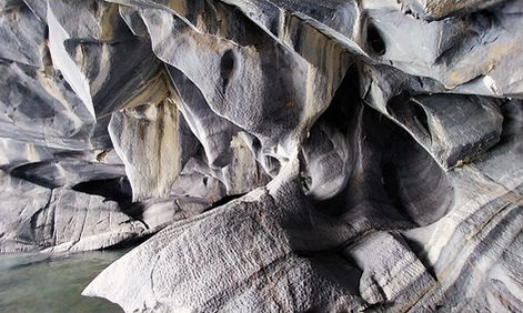
First stop was Puerto Sanchez, where we were shown a couple of small shipwrecks, one submerged and one resting on the shore. Thankfully this didn’t last long, and before we knew it we were on our way to our first set of marble caves. As we toured along the coast we could see numerous craggy inlets leading into small tunnels, but the dark shadows prevented us from seeing any details. Eventually the driver manoeuvred the boat a few metres into one of the caves, where the natural features became visible. Pale yellow stripes streaked across the surface of the grey, chiselled rocks, with protuberances extending down from the roof and forming intricate formations. Although it was a fascinating sight, I was expecting the colours to be more vivid and swirling in a dreamlike pattern, as was advertised in their promotional photos.
Next up was the more famous marble caves, which looked very similar to the first. Again we entered one of the inlets, admiring the astounding features in the marble. At one stage we could see out the other end of the tunnel, but the water was too shallow for us to use this as an exit. Once outside again, our guide pointed out shapes in the sides of the mountain that resembled animals, such as a dog and an elephant. It felt like he was just trying to stretch out the time.
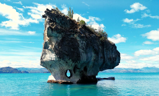
The final stage of the tour involved completing a loop around the larger Marble Cathedral and the smaller Marble Chapel, two rocks that jutted straight up out of the water. Apparently they were both official church locations, which have held several weddings and at least one funeral. Both contained caves and holes that allowed us to see through to the other side.
Overall, the caves didn't wow me as much as I expected. Online the photos looked out of this world, glistening with various shades of blue and reflections of the rock arches in the water. It was too turbulent today for any reflections, but we counted ourselves lucky that we could enter the caves at all - if it's too windy the boats stay outside, which would have been a waste of time. It was definitely much more impressive on the inside.
It was a speedy, rough and wet ride back to Rio Tranquilo, which would have almost been fun if my face didn't feel like it was frozen solid. We then had the unenjoyable task of driving 8 hours on the Carretera Austral to reach our next destination, Puyuhuapi. The first 2 hours were on gravel; it only took us 1.5 hours to get a flat tyre. After changing it on the side of the road, we had a nervous 2-hour drive to the next city, where we spent nearly another 2 hours finding a replacement (the hole was too big to repair we were informed). We ate dinner from a can on the side of a road, and we were utterly exhausted by the time we arrived in Puyuhuapi late at night.


